


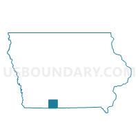
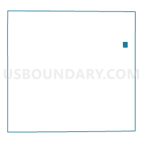
BEACONSFIELD Voting District, Ringgold County, Iowa
About
Outline
Summary
| Unique Area Identifier | 583329 |
| Name | BEACONSFIELD Voting District |
| County | Ringgold County |
| State | Iowa |
| Area (square miles) | 0.72 |
| Land Area (square miles) | 0.72 |
| Water Area (square miles) | 0.00 |
| % of Land Area | 99.92 |
| % of Water Area | 0.08 |
| Latitude of the Internal Point | 40.80722270 |
| Longtitude of the Internal Point | -94.05082540 |
Maps

Graphs
Select a template below for downloading or customizing gragh for BEACONSFIELD Voting District, Ringgold County, Iowa
Neighbors
Neighoring Voting District (by Name) Neighboring Voting District on the Map
- MONROE TWP W/O BEACONSFIELD Voting District, Ringgold County, IA
- UNION TWP W/O BEACONSFIELD Voting District, Ringgold County, IA